
Visual Description: Collage, pencil hand drawing and digital photographs of city scapes and architectural model. Showing the concept of This Is Not A New City.
THIS IS NOT A NEW CITY
2012 // THESIS PROJECT // AARHUS SCHOOL OF ARCHITECTURE [DK]
MANIFESTO
[ City Condition, part one ] [ Paris, part two ] [ Aarhus, part three ] [ The Model, part four ]
If you pay any attention to culture and history, you’ll accept there is no global solution to how we construct cities; however, there still exists a set of global conditions worth pursuing. The following text tries to identify these and investigate their implementation in European, and to some extent North American - cities.
If everyone agrees that we have to pursue densification of our cities, why then is most development still done after the modernistic tabula rasa method, expanding our cities by revoking more land, in order to place an object in the center of a plot?
It is time for architects to take responsibility. It’s our duty to lead the way; also when it gets tough. It is our responsibility, as architects, to investigate and develop strategies for living and dwelling in the future.
A city is a living organism, it thrives on life, and it must forever stay in motion to survive. A city cannot consist of only one thing - one center or one type - it must be made up of a multitude of centers, all with different characters; connected and interacting in numerous ways, creating a holistic common open network.
The development of our cities has resulted in separation, now we can talk about the city at the core of the urban structure and the periphery surrounding it. The city consists of streets, buildings, squares, and parks. It’s a gradient of space, from the public to the private, no two cities are alike, but the feel of a city is clear; the city condition.
The periphery is a confusing mixture of apartment blocks, terraced housing, villas, shopping centers, corporate headquarters, etc, all separated. There is a private feel to any given area, a distinct lack of identity. Is it utopian to think that we could bring the feeling of the city to these areas? Build structures on top of villas, connecting them in a network, inside the former residence; cafés and a locker room for joggers and bikers alike to start their venture on the new structures, climbing to the top of the apartment blocks, now dissected by new living situations. You no longer buy a house or apartment, but square meters, more or less connected, intertwined with one another. This isn’t an attempt to make every area like the city center, but it’s a quest to turn every area into a place. One could be a sports-like place, a garden-like place, a children-like place, etc. Since development occurs in existing areas, we do not need to claim more land.
In developing an architecture to overcome these obstacles, I urge that we turn to temporary architecture as the primary vessel for investigating and testing new ways of living; benefiting from the greater pace and degree of flexibility could inform us about new ways of producing city. For the only true test of architecture is to be found at the 1:1 scale, here and only here, can concepts be brought to life, tested over weeks, months, or years and bring forth answers about life. In this manner contributing to the production of city and where the periphery and the city merge, they will do so with varying centers competing and complementing each other generating a stronger city.

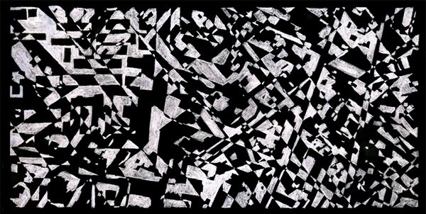
Visual Description: Hand drawing, ink on paper, 40 x 60 [inch]. Lines are drawn from the center to faceted outlines, creating a web of various densities. All individual shapes are tied together at the edges, creating on large fabric. The drawing represents the idea of a centerless city.

We use public space to communicate with one another, in various ways, in shaping it, marks, and prints. But who has the right to make statements? And what can one state? In New York [ July of 2008 ] I found a piece of street art questioning a budgetary decision made by the U.S. Department of the treasury, but this was an illegal statement, as it was put there without permission. At another place in the city, there was a huge banner, about four stories high, stating “Life is short. Have an affair in New York” depicting a woman in the process of removing a man’s pants, inciting adultery. This is legal, as the dating site, for which it advertises, has paid for this spot on the wall.

According to Martin Heidegger, space is something that has been made room for, something which starts at a boundary, i.e. dwelling comes from the notion of the cave. By solidifying public space, the air, surrounding our buildings, I arrive at a psychical translation of the built environment as space cleared for dwelling, even if dwelling does not occur. The cities in question are those of the Western world; I do not include the rapidly growing cities of Asia and Africa, as they go through a different evolution. I have located three different city structures, the grid [New York], the medieval city [Paris], and the ring city [Moscow]. I apply the method to the ground floor of each city and then proceed to superimpose these structures on top of one another. Moving from plan to section, I perform the violent act of the section to the superimposed cities; hereby creating a mastersection of the masterplans.
Visual Description: Drawing pencil on tracing paper; 280 x 135 [mm]. Superimposition of plans from, New York City, Moscow, Paris, and Aarhus. By inverting the drawing the spaces seem to be excavated from the mass, and at some point the drawing turns into a map; a highly fragmented map, with parallels to the cut-up method. It is no longer small figures or objects, but a condition, every space relates and depends upon its neighbors.

Visual Description: Hand drawing, pencil on paper; 420 x 297 [mm]. Tracing my movement around the school shows that on a daily basis, I move not only in the xy-plan but also extensively on the z-axis.

Visual Description: Collection of drawings, showing a line starting at the words “street” and ending at the words “trains”. The line crosses over, up, and down on multiple plateaus. The drawings are tracing the path walked from the street level to the platform at all Metro Stations visited during a study trip.


Visual Description: Three photos of the same model, made from wood, metal, and string. Thin metal rods are bent to create three-dimensional pathways hung with fishing string underneath a grid of metal rods, within an open wood box, the corner joints are crosses, allowing for disassembly. The pathways are made from the drawings above, and starting to speak to the public z-axises city.
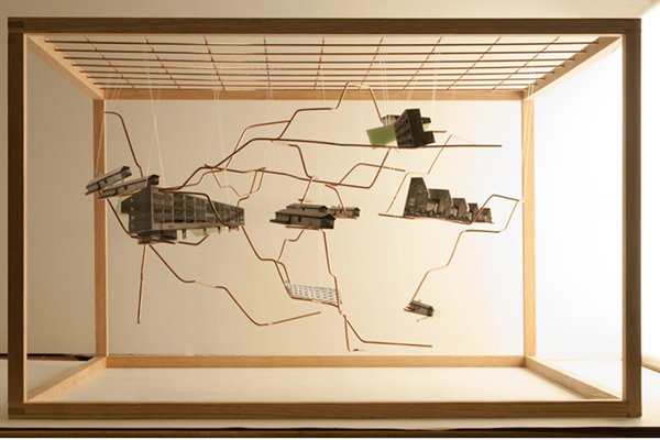
Visual Description: Model made from wood, metal, and string. Thin metal rods are bent to create three-dimensional pathways hung with fishing string underneath a grid of metal rods, within an open wood box. The metal rods are supporting digital black-and-white prints, of diverse housing solutions; remixing the existing city in the z-axis.

Visual Description: Hand drawing, ink on paper, lines drawn from side to side, attempting to follow each other, but often divergent, creating white spaces between them. The drawing is made while riding the Metro in Paris, registering the movement of the car, by attempting to draw fully parallel lines. Stations typically show up in the drawing as a while spot, given the effect the car coming to a stop has on the drawing motion.
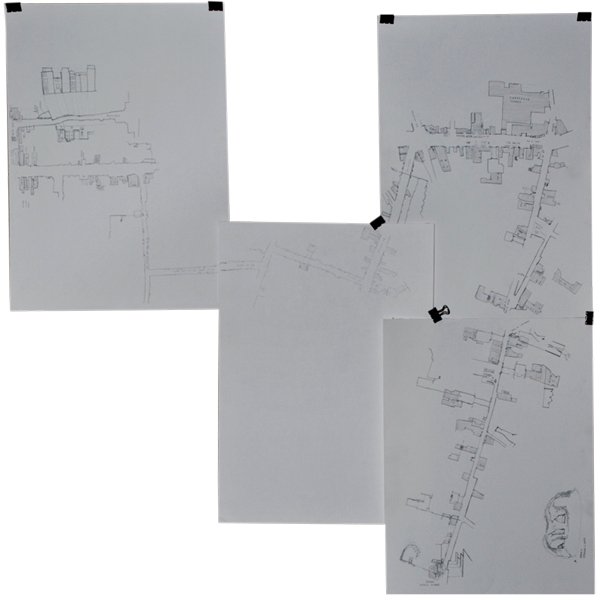

Visual Description: Map of Paris marked by hand with black ink lines. The lines describe all the spaces visited during the study trip. The long clear diagonal line, describes the section walk undertaken and shown in the model below.

Visual Description: The Section Walk Model, wood, leather strap, and digital color prints. Photographed on a black background. The model consists of wood slats, connected with a leather string and mounted photo slices from the section walk, together they describe an elongated street space, as well as the walk in time. See the conceptual drawing below.

Visual Description: The Section Walk Model, photographed on a black background, in plan and elevation. Given the high ratio between the height and width of the model, it can only stand if folded. These folds in time and space, brings together distinct areas of Paris, that are typically not considered connected. The folding also allows for the opportunity to fold the model to create an interior architectural space.

Visual Description: Hand and digital drawing. At the top is a series of photographs, a red rectangle is indicates area of the photo being collected and put together. The rectangle is starting at the furthest left and moving towards the right with each consecutive photo until reaching the far right side on the last photo. All the photos are from the Section Walk, all taken from the middle of the street, looking straight down the streetscape, typically placing plants and buildings on either side and empty sky in the center. This way the strips create an elongated street scape, as the composition between the individual photos are comparable.

Visual Description: Collage of distinct models, wood, metal, printed and marked by hand drawing in pencil. Exploring the concept of This Is Not A New City.


The neighborhood was established in the 1950s. The building files show that there have been many small modifications to the villas, mainly regarding permission to build a carport. Since the neighborhood is more than 50 years old, there are some beautiful old trees, worthy of preservation. To the north of the site, a green wetland is located, from here a path leads to the huge Lake Brabrand. The site slopes, from Skanderborgvej towards Lykkeholms allé [ a drop of 5-8 meters ], enabling a view over the wetlands.

An investigation into the different structures of the city reveals, that by comparison the structure of the city and the suburbs are quite identical; a multiple-dwelling-block fits almost perfectly, on top of a single-family-block. This lead to an investigation into ground area / floor area use and density, the numbers and calculations are in the appendix at the end of this pamphlet. The site used for the comparison is a single-family-block bordering on Skanderborgvej. The multiple-dwelling-block is assumed to be approximately 10 meters deep and five stories high. This shows the multiple-dwelling-block uses roughly 3 times as much ground area, but delivers about 15 times as much floor area.


Visual Description: Large-scale wood architectural model of This Is Not A New City. The model was used as an exploration of free-growing structures, creating a multitude of spaces open/close/tight/tall/wide/etc. This is in recognition of the multitudes that inhabit the city. Here existing single-family homes at the bottom of the structure have been overgrown by a mix of open wireframe and slab and column structures. In this process, the program of the single-family home is open to evolve. The open structures enable the inhabitants to build flexible living units by engaging in conversations amongst the community.
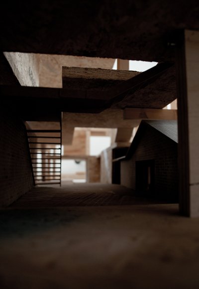
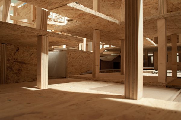

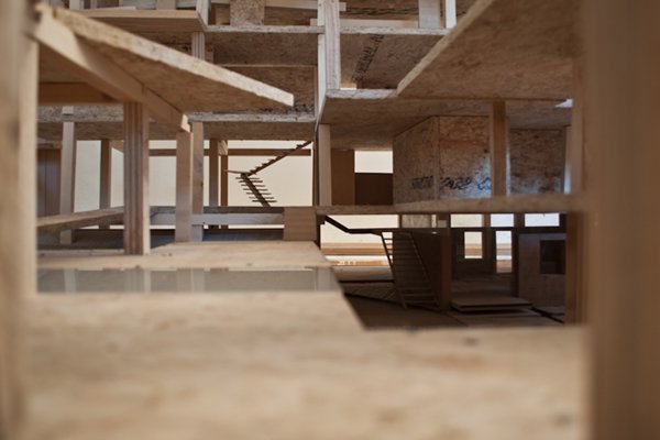

Visual Description: Large-scale wood architectural model. Existing single-family homes at the bottom of the structure have been overgrown by a mix of open wireframe and slab and column structures. The open structures enable the inhabitants to build flexible living units by engaging in conversations amongst the community.